A ridge between two bays, not a mountain
Vrmac is the wooded spine that separates the inner Bay of Kotor from the Tivat side of the water, running roughly north-west from behind Kotor towards Tivat. It tops out at around 785 metres, at a peak locally called Sveti Ilija, well short of Lovćen’s 1,749 metres, but that lower altitude is exactly why it works as a half-day hike rather than a full expedition: no toll road, no need for a car, and a starting point you can walk to from your hotel in Kotor’s old town.
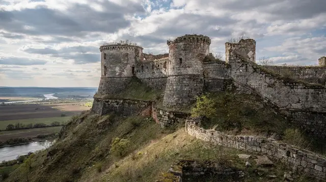
What makes Vrmac worth the climb is not the peak itself, which is unremarkable scrub and rock, but the ruined Austro-Hungarian fort near the top and the old military road that gets you there. Both date from the empire’s decades of building coastal defences around the bay, the same period that put fortifications above Herceg Novi and along the water at Prevlaka. The road was cut to move troops and supplies between the Kotor garrison and the Tivat side without descending to sea level, and much of it is still intact enough to walk today, wide, graded, and shaded in patches by pine and holm oak.
Getting to the trailhead without a car
There are two realistic starting points, and neither requires a rental car.
The first is from Kotor itself: walk out of the old town past Dobrota or up through the residential streets behind the walls, and pick up the marked path that climbs into the trees. This adds 30 to 45 minutes of uphill walking before you even reach the old military road proper, so it suits people already comfortable with a longer day.
The second, and the one most locals and tour operators use, is from Muo, a small waterfront village a few minutes west of Kotor along the coast road, easily reached on foot in 20 minutes or by taxi in under 10. A path climbs from Muo directly onto the ridge and joins the Austro-Hungarian road higher up, cutting a meaningful chunk off the total ascent. If you are short on time or energy, starting from Muo rather than the old town is the difference between a 3-hour outing and a 4-hour one.
Public buses do not serve either trailhead directly, so it is walk or taxi. A taxi from the old town to Muo should cost only a few euros, but confirm the price before getting in, since meters are rarely used with tourists at the port and in town.
| Starting point | Distance to fort | Round-trip time | Best for |
|---|---|---|---|
| Kotor old town, on foot | ~5-6 km one way | 4-4.5 hours | No transport needed, fitter hikers |
| Muo, on foot | ~3.5-4 km one way | 3-3.5 hours | Shorter day, still car-free |
| Prčanj side (occasional variant) | ~4 km one way | 3.5-4 hours | Hikers already staying in Prčanj |
The old military road and the fort
Once you join the Austro-Hungarian road, the walking gets easier even as the gradient continues, because military engineers built it wide and consistently graded for mules and carts rather than for infantry scrambling straight up a slope. It switches back through pine forest with the Bay of Kotor dropping away on the right for most of the ascent, and on clear days you get repeated views back over the water long before you reach the top, unlike on Lovćen’s old road through Njeguši, which stays enclosed until much higher up.
The fort itself is a ruin: roofless stone walls, gun emplacements long since stripped of anything metal, and no interpretive signage explaining what you are looking at. There is no ticket booth and no fixed opening hours, because there is nothing to guard and no one collecting money. That also means no safety barriers, no lighting inside the structure, and no staff if you turn an ankle on loose stone, so a torch, decent shoes and a charged phone matter more here than at a managed site like San Giovanni fortress above Kotor.
From the fort walls and the open ground just below them, the view takes in the whole inner bay at once: Kotor and its walls directly below, Dobrota and Prčanj strung along the water to the north, and on a clear day the outer bay opening past Herceg Novi towards the Adriatic. It is a wider, more complete view of the Bay of Kotor’s shape than you get from most points along the shore, precisely because Vrmac sits in the middle of it rather than at one end.
Vrmac versus Lovćen: the honest comparison
Both hikes end in a panorama over the Bay of Kotor, and both involve an old road built for something other than tourism. The real differences are access, cost and crowding.
| Vrmac ridge | Lovćen National Park | |
|---|---|---|
| Peak elevation | ~785 m | 1,749 m |
| Reach without a car | Yes, on foot from Kotor or Muo | No practical option; taxi or tour needed |
| Entry fee | None | National park fee applies |
| Crowds | Light, even in August | Moderate to heavy at the mausoleum viewpoint |
| What’s at the top | Ruined fort, open views | Njegoš mausoleum, higher and more distant views |
| Round-trip time | 3-4 hours | Half a day including drive |
Lovćen wins on sheer altitude and on the mausoleum itself, which is a genuine monument worth seeing in its own right. Vrmac wins on logistics: no vehicle, no fee, no queue at a gate, and a view of the bay’s full outline that some visitors who have done both hikes actually prefer, since Lovćen’s higher vantage point can flatten the bay into a smaller shape in the distance. If you already have a car and want both, doing Lovćen and the old road through Njeguši as a separate day trip and Vrmac as a car-free half-day makes more sense than trying to combine them.
Planning the hike: timing, water, footwear
Start early. There is very little shade on the lower slopes near Muo, and by mid-morning in July or August the exposed sections get hot fast. Aim to be on the trail by 7:30 or 8am if you are hiking between June and September, and treat anything after 10am as a poor time to start the climb, not just the summit push.
Carry at least 1.5 litres of water per person; there is no tap, spring or kiosk anywhere on the route. A hat and sun cream matter as much as footwear, since long stretches of the old military road sit in full sun even though the surrounding forest looks shady from below. Trainers with decent grip are fine for most of the ascent, but the final approach to the fort has loose stone that rewards proper hiking shoes.
Mobile signal is inconsistent along the ridge, particularly on the Tivat-facing side, so download an offline map or GPS track before you set out rather than relying on a live connection at a junction. The old military road is easy to follow underfoot once you are on it, but several forest paths cross it without clear signposting, and it is simple to end up on the wrong fork if you are navigating from memory.
Rain changes the calculation quickly. The stone surfaces on the steeper sections become slick, and the exposed ridge is not somewhere you want to be in a lightning storm; if the forecast looks unstable, this is a day to swap for something lower and covered, such as Kotor’s old town on foot or a museum visit instead.
If you’d rather not navigate it alone
Independent hikers manage the route without a guide, since the old military road is straightforward once you find it, but a guided option removes the navigation uncertainty and usually adds context on the fort’s history that no signage on site provides. A half-day guided hike up Vrmac with a local leading the way covers exactly this route and handles the trailhead logistics for you.
For a smaller group or a pace set to you rather than a fixed departure time, a private Vrmac hiking tour is worth the extra cost, particularly if you are travelling with someone who needs more frequent stops. If walking uphill for three hours does not appeal but you still want the summit view, an electric mountain bike trip up Vrmac reaches the same ridge with far less physical effort, using tracks that a standard hire bike could not manage.
Anyone weighing Vrmac against the bigger mountain nearby can also book the private tour to Lovćen and the Njegoš mausoleum and compare both viewpoints on separate days rather than choosing blind.
Where this fits in a Kotor itinerary
Vrmac works best as a half-day slotted into a longer stay rather than a single-day visit’s main event, since it needs a clear morning and offers little for anyone spending less than two or three nights in the bay. If you are planning how many days to spend around Kotor, Vrmac is a reasonable addition once you have already covered the old town and a boat trip, not a replacement for either. It also slots naturally into a car-free Kotor itinerary, since it is one of the few genuine viewpoints over the bay that does not require a rental car, a tour bus, or the Lovćen entrance fee.
Base yourself in Kotor’s old town or in Dobrota if you want the shortest possible walk to either trailhead; staying further out in Tivat or Budva turns a half-day hike into most of a full day once transfers are added. For hikers who want more of this kind of walking, the ladder of Kotor route up to San Giovanni fortress and the climb inside San Giovanni itself cover similar ground closer to town, while category browsing under hiking and nature lists the rest of the bay’s trails in one place.
Vrmac ridge hiking FAQ
Can you hike Vrmac ridge without a car?
Yes, and that is its main advantage over Lovćen. The trail starts on foot from Kotor’s edge or from the village of Muo, both a short walk or taxi ride from the old town, with no toll road or parking to arrange.
How long does the Vrmac hike take?
Budget 3 to 4 hours round trip for the main route to the fort and back, depending on your pace and how long you linger at the viewpoints. Fit hikers moving briskly can do it in under 3 hours.
Is the fort on Vrmac ridge open to visit?
The Austro-Hungarian fort is a roofless ruin with no ticket booth, no fixed hours and no entry fee. You can walk through the outer walls, but there is no lighting, signage or safety barrier, so a torch and daylight matter more than opening times.
Is Vrmac ridge better than Lovćen for the view?
Lovćen sits higher and includes Njegoš’s mausoleum, but Vrmac is closer, free, reachable without a car, and much less walked. For a single photograph of the whole Bay of Kotor in one frame, hikers who have done both often rate Vrmac as good or better.
What should I bring for the Vrmac ridge hike?
At least 1.5 litres of water per person, sun protection, sturdy shoes rather than sandals, and a phone with the route downloaded, since signal is patchy on parts of the ridge. There is no water source, café or shade for most of the climb.
Can you drive to Vrmac fort instead of hiking?
A rough track reaches close to the fort from the Tivat side and is sometimes used by 4x4 tours and e-MTB operators, but there is no paved public road and no parking area near the summit. Most visitors arrive on foot.
Is the Vrmac trail signposted?
Partially. The old military road itself is easy to follow underfoot, but junctions are not consistently marked, and several forest paths cross it. A GPS track or offline map is worth carrying rather than relying on signage alone.